Overview of the Iyai Rock-Shelter Site
Location of the Iyai Rock-Shelter Site
The Iyai rock-shelter site is located at 36°33’28.29″ N latitude and 138°38’50.25″ E longitude in Kaise, Naganohara Town, Agatsuma District in northwestern Gunma Prefecture. It is located on the southern edge of the Jōshinetsu mountains, which sttradle Gunma, Nagano, and Niigata prefectures, at an elevation of 649m above sea level. The town area is overlooked by Mt. Kusatsu-Shirane (2171 m) to the northwest, Mt. Asama (2568 m) to the southwest, and other mountains over 1,000m high such as Mt. Ojō (1123 m) and Mt. Takama (1123m) are located within the town itself. The area lies in the basin of the Shirasuna river, a tributary of the Agatsuma river, which is a part of the Tone River system (Figs. 1 and 2).
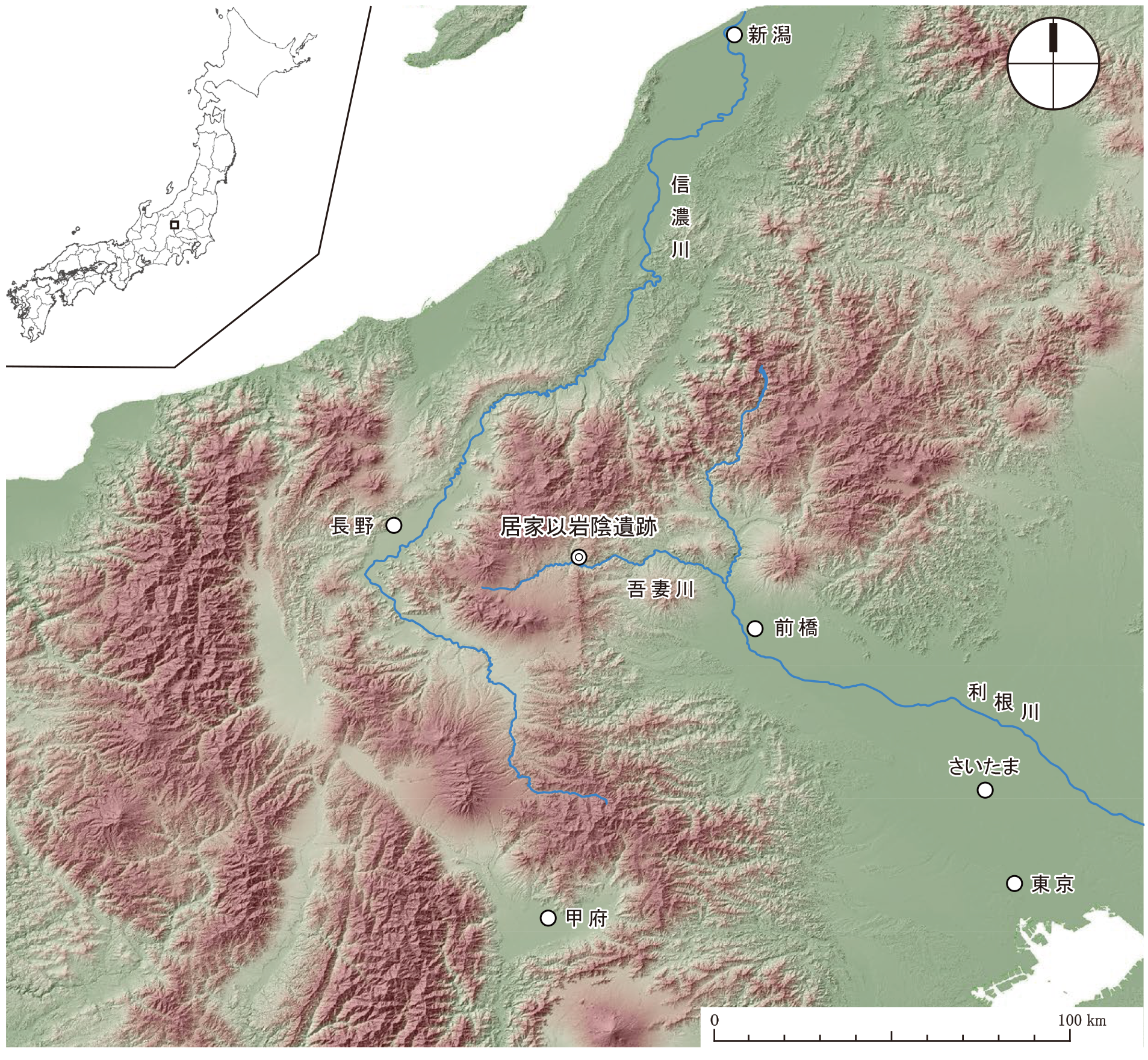
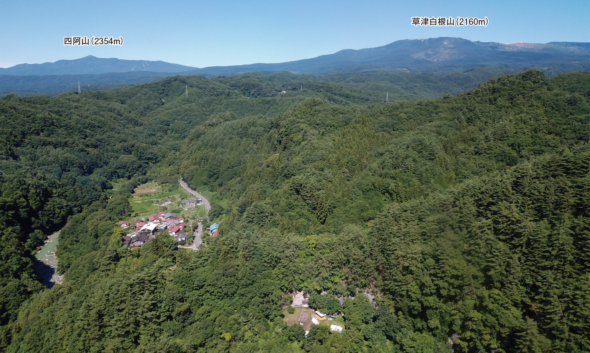
The rock-shelter was formed by the erosion of an outcrop of welded tuff by the Fukasawa River, which flows down the western foot of Mt. Ojō. Six rock shelters have been identified in the vicinity of the site, the first of which is currently under investigation. It is currently about 20m wide, 6m high, and 4m deep, and opens to the south-east. In front of the rock shelter there is a slope with a gradient of about 15 degrees, known as the ‘slope in front of the terrace’ (Figure 3).

The Iyai rock shelter site exhibits evidence of frequent use, especially during the Initial Jomon period. It is thought that Initial Jomon people chose this site as their base of operations because of its favorable location. If you travel up the Shirasuna river for about 20 km, you can easily reach the border between Gunma and Niigata prefectures, and if you go down the valley of the Nakatsu River, which flows into Niigata Prefecture from Lake Nozoriko (an artificial lake built on the marshland of a former crater lake), you will pass through Akiyamago and enter Tsunan Town in Niigata Prefecture, where the Shinano river terrace geopark is located. It is also possible to reach the Ueda and Saku basins in Nagano Prefecture via the Shinetsu border plateau by following the Agatsuma River, which is only about 2km away. Furthermore, if you head downstream along the Agatsuma River, you can enter the Kanto Plain by following the Tone River system. It is thought that the valleys created by the ridges of the Jōshinetsu border and the Agatsuma River system were also important travel routes during the Jomon period. The location of the Iyai rock shelter site would have been advantageous to the Initial Jomon people, who lived in the mountains and highlands and travelled between different regions.
Chronology and Stratigraphy of the Iyai Rock Shelter Site
(1)Chronology of the Iyai Rock Shelter Site
Artifacts from many periods ranging from the Jomon period to historical times have been excavated, with the majority dating to the Initial Jomon period (approximately 11,300-7,200 years ago). The most numerous include Oshigatamon and Chinsenmon style pottery from the middle part of the Initial Jomon Period, Jokonmon style pottery from the latter part of the Initial Jomon period, and Kaitenjomon, Hyorijomon, and Yoriitomon styles, as well as unmarked pottery, all dating to the early part of the Initial Jomon period. More than 7,000 sherds (as of 2023) have been excavated, with the Oshigatamon style including Hizawa and Hosokubo types, the Chinsenmon including Mito, Tado-kasou, Kannoki, Hannogiyama Nishi, Kanbayashi Nakamichi Minami types, and the Jokonmon style including Shiboguchi, Nojima, and Ugajimadai types. There are also newly discovered types that have not yet been classified. This wide range of pottery is an important sample of the early pottery in the Jōshinetsu region.
(2)Stratigraphy and Layers Containing Artifacts
Excavation is underway in three areas: inside of the rock shelter (protected from rain), on the terrace in front of the rock shelter (which is currently a path), and on the “slope in front of the terrace”. The excavation area covers approximately 24m2 inside of the rock shelter, 4m2 on the terrace, and 27m2 on the “slope in front of the terrace”.
The stratigraphy of the rock shelter can be roughly divided into the following groups: a surface layer (containing modern material), Layer I (brown earth: Early to Late Jomon period), Layer II (grayish dark brown earth: Initial Jomon and Early Jomon period), a bedrock gravel layer (no artifacts), and Layer III (brownish gray earth: Initial Jomon period) (Fig. 4). The ash deposited in the rock shelter is slightly alkaline based on pH measurements and is composed mainly of calcite (crystals of calcium carbonate CaCO3) according to X-ray diffraction.
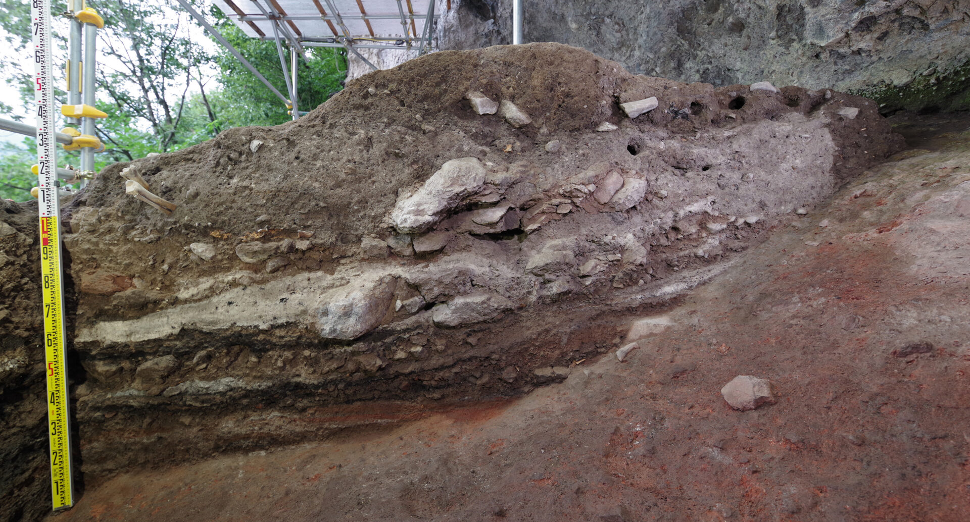
An ashy brown earth (middle part of the Initial Jomon period, at least 1m thick) containing large amounts of ash and organic matter such as animal bones, plant seeds, and charred wood was also identified in the trench on the “slope in front of the terrace”. The pottery excavated from this ashy soil layer (layer 10) consists mainly of Oshigatamon style pottery with Daenmon and Yamagatamon patterns. Seven overlapping layers were observed, but radiocarbon dating of the carbonized material excavated from each layer is concentrated in the range of 8965-8863BP, and its calibrated age is 10,200-9700 cal BP. It is estimated that this is a subsistence waste layer approximately 10,000 years old formed during the time of the pottery. During the excavation of the “slope in front of the terrace” area, we collected large quantities of animal and plant remains encapsulated in the ashy soil and have so far conducted approximately 9,800 liters of soil washing and sorting (via sieving and flotation) to recover all artifacts larger than 1mm in size. These are valuable materials that reveal in particular the animal and plant resource utilization and environmental adaptation of the Initial Jomon populations that formed this site.
Yasuhiro Taniguchi